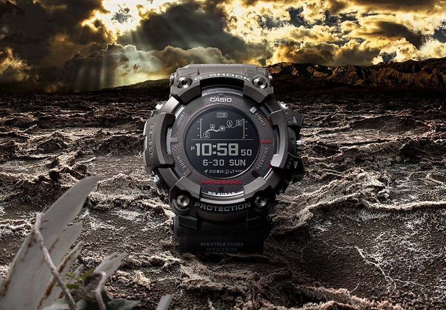
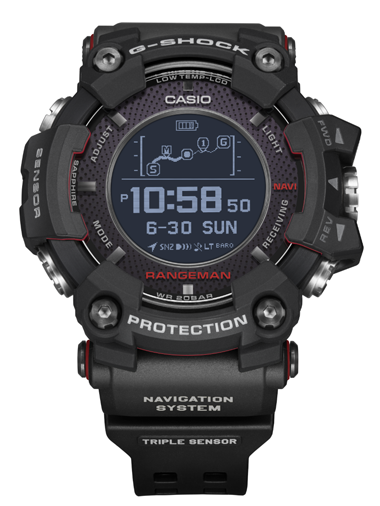
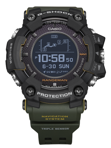
Tokyo, January 10, 2018 — Casio Computer Co., Ltd. announced today the release of the latest addition to its RANGEMAN series of watches, which support the wearer even in survival situations. The new GPR-B1000 features the world's first* solar-assisted GPS navigation and will be available in two models.
- Based on a Casio survey as of January 10, 2018.
The RANGEMAN is part of the "Master of G" series of watches designed for use in the most extreme conditions. RANGEMAN watches incorporate Triple Sensor to measure compass bearing, atmospheric pressure/altitude, and temperature, based on the concept of "Survival Toughness."
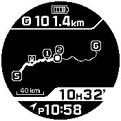
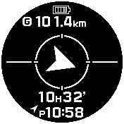
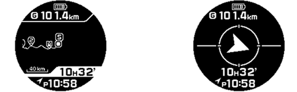
In addition to Triple Sensor, the new GPR-B1000 is capable of GPS navigation—a first for a G-SHOCK watch. The watch collects location data from GPS satellites to display the current location on a route or bearing to a destination, in real-time. The watch also saves track and point data (including longitude/latitude, altitude, and temperature) in memory.
Using Bluetooth®, the watch pairs with a smartphone to connect with the G-SHOCK Connected app, allowing the user to create routes or manage log data in the app. Tracks and point data saved in memory are displayed on a 3D map or as a timeline. The watch also receives data from time servers to keep accurate time anywhere in the world.
The GPR-B1000 features dual wireless and solar charging systems. The GPS functions are usable for approximately 33 hours on a wireless charge of about five hours. Even if the battery level drops below a usable level for GPS while outdoors, solar charging can be used to resume GPS functions for a limited time. The time display is kept powered at all times using solar charging, regardless of the status of GPS functions.
The GPR-B1000 delivers toughness in construction and materials, with a dust- and mud-resistant structure and carbon fiber insert band. Designed for the ultimate in survival toughness, the GPR-B1000 is the latest evolution of G-SHOCK.
Model |
Belt Color |
|---|---|
GPR-B1000-1 |
Black |
GPR-B1000-1B |
Khaki |
Main Features of GPR-B1000
GPS Navigation
- Navigate and Log
The watch collects location data from GPS satellites to display the current location on a route or bearing to a destination, in real-time. Turn on GPS navigation to automatically record tracks with either four-second or one-minute interval recording. (Save up to 20 tracks in memory.)
- Backtrack
The watch helps users navigate back to where they started, using track data to display the route back to the starting point and bearing.

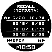
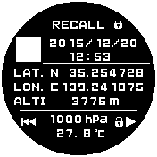
- Point Memory
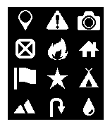
The user can save point data (including date/time, longitude/latitude, altitude, atmospheric pressure, and temperature) by just pushing a button. Set point icons to indicate the type of point. (Save up to 60 points.)
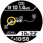
Save points with the push of a button
Bluetooth Smartphone Pairing to Connect with G-SHOCK Connected App
- Receive data from time servers to keep accurate time anywhere in the world.
When paired with a smartphone, the watch receives data from time servers to keep accurate time anywhere in the world. Easily configure world time cities, alarms, and timers from the G-SHOCK Connected app.
- Start/End Point, Route Setting
Set the start/end points to use GPS to navigate to a destination and create routes.
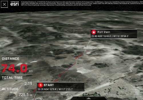
- Display Tracks on 2D or 3D Maps
Display saved tracks on a 2D or 3D map in the G-SHOCK Connected app.
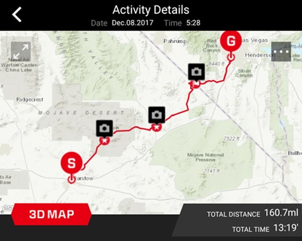
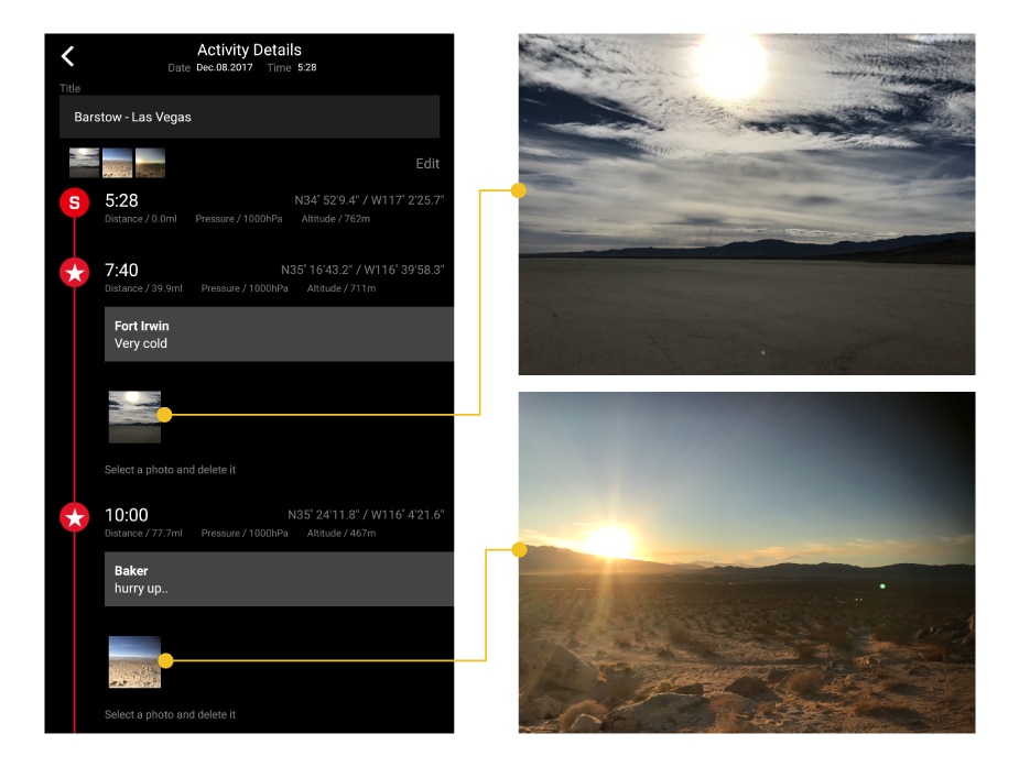
- Timeline display of waypoint data
Display saved waypoint data in a timeline. View photos taken with the smartphone while using GPS navigation, in the timeline.
Solar and Wireless Charging
The GPR-B1000 is equipped with dual wireless and solar charging systems to support activities in the outdoors. GPS navigation is usable for approximately 33 hours on a wireless charge of about five hours. If the battery becomes depleted, GPS functions can be resumed by charging the watch in bright light. (GPS functions are usable for one hour on a solar charge of approximately four hours in 50,000 lux conditions.) Regardless of the status of GPS functions, solar charging keeps the time display powered at all times.
Ceramic Case Back—A First for G-SHOCK
The watch uses a ceramic case back to support wireless charging and high-sensitivity GPS reception. The case back uses a 2.0 mm thick ceramic material, making the watch shock-resistant and waterproof down to 200 meters.
Tough Construction to Withstand Harsh Conditions
The watch is designed to withstand harsh conditions with dust- and dirt-proof, mud-resistant construction, low-temperature resistance down to -20°C (-4°F), a carbon fiber insert band, and sapphire crystal.
Specifications
Construction |
Shock-resistant; low-temperature resistance (-20℃ / -4℉); mud-resistant |
|||
|---|---|---|---|---|
Water Resistance |
200 meters |
|||
GPS Signal Frequency |
1575.42 MHz |
|||
GPS Signal Reception |
Time-calibration (auto*1, manual); acquisition of position information (manual) |
|||
Communication Specifications |
Communication Standard |
Bluetooth® low energy |
||
Signal Range |
Up to 2 meters (may differ depending on surrounding conditions) |
|||
GPS Navigation |
Activity logs (up to 20 logs), track
display (wide area map/magnified map switching), start-to-destination
direct distance, bearing to destination, destination setting from Point
Memory recordings, backtrack, activity time measurement, log use status |
|||
Point Memory |
Up to 60 sets of point data (time, date, longitude/latitude, altitude, atmospheric pressure, temperature), point icons |
|||
Digital Compass |
Measures and displays direction as
one of 16 points; measuring range: 0° to 359°; measuring unit: 1°; 60
seconds continuous measurement; bidirectional calibration and magnetic
declination correction; bearing memory (records and display one set of
degree and direction); graphical display of north, south, east and west;
auto horizontal compensation |
|||
Barometer |
Measuring range: 260 hPa to 1,100 hPa
(7.65 inHg to 32.45 inHg); measuring unit: 1 hPa (0.05 inHg);
atmospheric pressure tendency graph (past 48 hours graph display);
atmospheric pressure tendency alarm (arrow indicates significant
pressure changes) |
|||
Altimeter |
Measuring range: -700 m to 10,000 m
(-2,300 ft. to 32,800 ft.); measuring unit: 1 m (5 ft.); relative
altitude readings (-3,000 m to 3,000 m); altitude tendency graph |
|||
Thermometer |
Measuring range: -10℃ to 60℃ (14℉ to 140℉); measuring unit: 0.1℃ (0.2℉) |
|||
World Time |
39 cities (39 time zones*2, daylight saving on/off) and Coordinated Universal Time; auto summer time (DST) switching |
|||
Stopwatch |
1 second; measuring capacity: 999:59'59; measuring modes: elapsed time, split time |
|||
Countdown Timer |
Measuring unit: 1 second (maximum 24 hours) |
|||
Alarm |
4 daily alarms (with snooze alarm) |
|||
Other Functions |
Mobile Link functions (world time:
over 300 cities, auto time adjustment, One-Touch Time Adjustment, easy
watch setting, phone finder, route setting and log data management in
GPS navigation, tide graph, moon data); day and date display; full
auto-calendar; auto LED backlight with afterglow: 1.5/3.0 seconds;
battery level indicator; 12/24-hour format; airplane mode; button
operation tone on/off; sunrise/sunset time display |
|||
Power Source |
Solar powered system (solar-charging
system), charging system compatible with wireless chargers (requires
device with Type-A USB terminal) |
|||
Continuous Operation |
With GPS use
Approx. two months more for non-GPS functions About 29 months with the power-saving function*3 ON after full charge |
|||
Size of Case |
60.3 × 57.7 × 20.2 mm |
|||
Total Weight |
Approx. 142g |
|||
- *1GPS signals are received automatically when the watch recognizes they are available in the area.
- *2May be updated when connected to a smartphone.
- *3Power-saving after a certain period in a dark location
- The Bluetooth® word mark and logos are registered trademarks owned by Bluetooth SIG, Inc. and any use of such marks by Casio Computer Co., Ltd. is under license.